Community Corner
Trees Explained With The Click Of A (Smart) Phone
Get some help learning about trees from the Smithsonian and your phone.


What’s that tree?
If you’re walking through Union County’s Lenape Park, you’ll be able to find out with some help from The Smithsonian.
With guidance from Union County's Master Tree Stewards, a new generation of tree identification signs was installed along the new 1.5-mile Lenape Park path that passes through Cranford, Kenilworth, Springfield and Union. The path is also part of the East Coast Greenway, a 2,950-mile lowland Appalachian Trail from Maine to Florida that weaves through nearly every major city along the East Coast. (www.greenway.org/)
Find out what's happening in Cranfordwith free, real-time updates from Patch.
In recent years, tree stewards installed ID signs in Echo Lake and Nomahegan Parks, which are also part of the Union County Parks System.
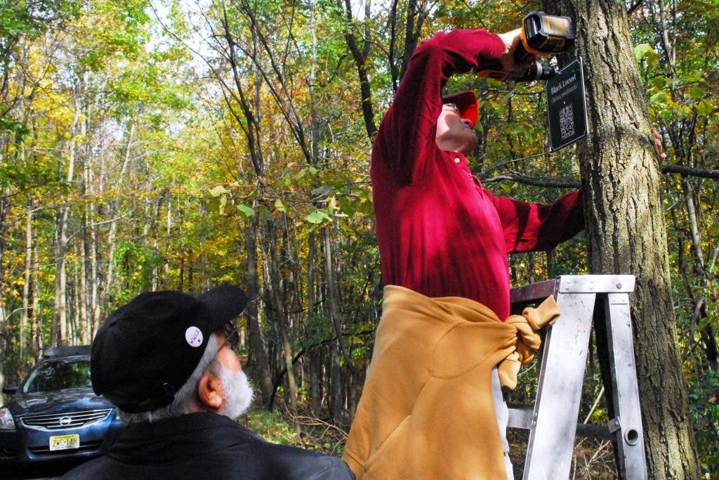
While the original signs had the traditional English and Latin names for a tree, these new signs take advantage of Leafsnap, (www.leafsnap.com) an electronic field guide developed by researchers from the Smithsonian Institution, Columbia University and the University of Maryland. (While Leafsnap was originally designed to work with the iPhone and other Apple products, the system was modified by County Parks staff to facilitate access to the field guide from any brand of smartphone.)
Find out what's happening in Cranfordwith free, real-time updates from Patch.
To access the Leafsnap field guide, park users with smartphones or tablets simply scan the QR code that is now part of this new generation of tree ID signs. Those squiggly-lined black boxes connect to a webpage that describes the tree, complete with high-resolution images of leaves, flowers, fruit, petiole and seeds.
“One of the nicest aspects to this project is that it enables anyone walking through the woods with a smartphone to have a field guide at their fingertips,” said
Freeholder Bette Jane Kowalski, who often walks through the county’s parks for exercise. But there is also another aspect to the program, although perhaps not as overt.
“We’re also hoping that this convergence of nature and technology may spur more interest from children,” Kowalski said. “All you have to do is look at young people today--that phone is always in their hands. This is a way to get them to learn more about the environment around them through a device that has become a major part of their lives, whether we like it or not.”
“If we can tap into their curiosity at that moment, and enable youngsters and adults alike to immediately access the Leafsnap database, and learn all about the tree standing right in front of them, who knows where that might lead?”
On a recent sunny morning, Tree Stewards Ken Ilgavizis and Dean Talcott, a retired county engineer, worked together with Kevin Reddington, the supervisor of the county’s Shade Tree division, to install the new signs.
Twelve species of trees were identified along the trail, Talcott said, explaining that those dozen trees represented the vast majority of the trees in Lenape.
“We weren’t really doing a tree survey,” Talcott said. “We focused on the trees along the path.”
The trees were identified in multiple locations, along with a sign for poison ivy, which while not a tree, was important for park visitors to recognize, he said.
Talcott, a Master Tree Steward for 10 years, estimates he has taught tree identification to upwards of 2,000 youngsters over the years as part of programs sponsored by the Rutgers Cooperative Extension of Union County. And interest among adults seems to be growing, with nearly 30 people taking the most recent classes on tree identification, one of the biggest classes ever, he said.
Get more local news delivered straight to your inbox. Sign up for free Patch newsletters and alerts.


